FIRST CHRISTIAN CHURCH
Site of Colonial District Committee
Meetings at 7:30 p.m.
on the Fourth Wednesday of Each Month and
the Colonial District Commissioner Leadership Team
Meetings at 7:30 p.m. on the Fourth Thursday
of Each Month
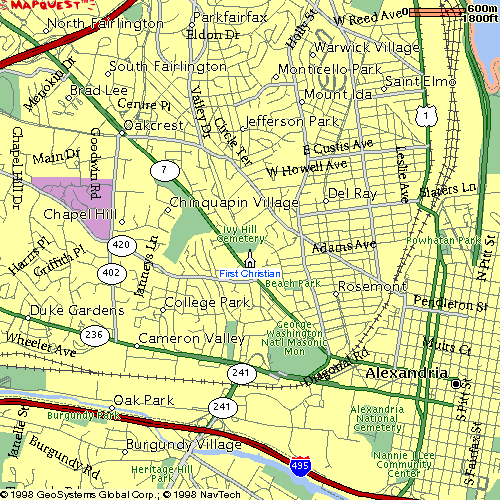
| First Christian Church is at 2723 King Street, about 0.7 miles northwest
of the George Washington National Masonic Memorial on the west side of Old Town
Alexandria. To reach it: From the east: Head northwest on King Street (VA-7) from the first stop light after you have passed under the railroad tracks on the west side of Old Town Alexandria. (Callahan Drive comes into this corner from the south; Russell Road from the north. The corner is just south of the Amtrak station.) Continue northwest on King St. for about 0.7 miles, watching for the driveway to the church on the right. If you reach the Woodbine senior housing complex or Ivy Hill Cemetery, you have gone too far. From the west: Head southeast from Quaker Lane on King Street (VA-7) for about 1.2, watching for First Christian Church on the left just after you pass Ivy Hill Cemetery and the Woodbine senior housing complex. (An alternate for those coming from the west on Seminary Road (VA-420) is to cross Quaker Lane (VA-402) and continue east on this arterial (whose name changes to Janney's Lane) for another 1.0 miles until it dead-ends at King St. Turn left on King St. and go northwest for one block, turning right into the church driveway before you reach the church, Woodbine, or Ivy Hill Cemetery. From the south: Head north onto Telegraph Road (VA-241) from the Capital Beltway (I-95), staying in the left or middle lane. Proceed around the long, looping ramp onto westbound Duke Street (VA-236). Continue west on Duke St. for about 0.5 miles. Turn right onto Cambridge, whose intersection with Duke St. has a traffic light and Generous George's original restaurant on the southwest corner. Bend up the hill and pass Bishop Ireton High School, continuing north on Cambridge for about 0.5 miles. Turn right to head east onto Janney's Lane for about 0.5 miles until it dead-ends at King St. Turn left on King St. and go northwest for one block, turning right into the church driveway before you reach the church, Woodbine, or Ivy Hill Cemetery. From the east: Turn west off of the George Washington Memorial Parkway onto Collingwood Road. Head west on Collingwood for about 0.4 miles to the Fort Hunt Rd. intersection, which has a traffic light.
|
![]()
This page was last updated on 01/22/99.
Copyright © 1999, Colonial District, All Rights Reserved